Best Hikes in North Carolina | Mountain, City and Coastal Trails
Joining us for a guided tour of must-do hikes in North Carolina is Randy Johnson. Randy has enjoyed a long career as a travel writer, and has authored several award-winning books and travel guides about all the best NC hiking trails. Add to that his experience as a map maker and photojournalist, his books raise the bar to deliver excitement that will convince you North Carolina is worthy of a hiking vacation.
Hiking in NC brings a new set of challenges for the body. Regardless of whether you’re a seasoned hiker or a motorist touring the Blue Ridge Parkway who maybe doesn’t hike that much (but wants to), it’s helpful to do some targeted exercises to get ready. Schedule a complimentary fitness consultation with Marcus Shapiro or check out Fit For Trips’ custom training programs.
Does North Carolina Have Good Hiking?
I have got to say that North Carolina is one of the top states in the country to put on a pack and head up a trail. The hiking in North Carolina is excellent.
North Carolina is home to the Great Smoky Mountains. It’s the most-visited national park in the country, with 12.1 million visits recorded in 2020. Additionally, the Blue Ridge Parkway is the most visited park administered by the National Park System. It was #1 in recreation visits in 2020, with 14.1 million visits. So, if you’re going to let the visitors of our national parks vote for the best state to hike in, the country is voting for North Carolina.
Too few people realize that the highest mountains in eastern America are in NC—not New England, as some assume. For comparison, there’s only one summit in New England above 6,000 feet, New Hampshire’s Mount Washington, which stands at 6,288ft. North Carolina has 60 peaks above 6,000 feet, more than a dozen higher than Mount Washington.
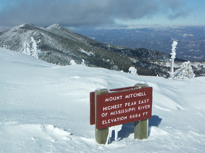 At 6,684 feet Mount Mitchell is the East’s highest peak, one of many nearly 7,000-foot summits in the Black Mountains between Boone and Asheville. Mitchell is accessible from the Blue Ridge Parkway, which is often closed in winter.
The state has so much variety in terms of scenery and biodiversity on the trails. The range of experiences in North Carolina, from alpine zones in the western mountains all the way to the coast, which is a subtropical archipelago, is wildly diverse. Because the ecosystems across the state are so diverse, the experience hiking in NC is really unique.
You’ll experience different vegetation and soil characteristics. In the southern Appalachians and the higher mountains, you’ve got tremendous rock outcrops, including granite and quartz. You can hike some very lofty elevations, but you also have deep valleys with wonderfully diverse, mixed deciduous forests and evergreen forests. The higher you go, the more Canadian forest you see, spruce and fir. The lower you go, the bigger the rivers and streams and the more diverse the deciduous forests. That range of elevation and tree types creates a blazing, more than month-long autumn color season.
Best Towns and Cities to Hike in North Carolina
Hiking around Asheville
Asheville is a quintessential mountain town. It’s second only to Miami Beach for the most art deco architecture in the southeastern United States. It’s a hip, happening place. People want to go there for great restaurants, the live music scene, and southern Appalachian culture.
So, if you’re visiting Asheville to experience all that, where are you going to go to hike? There’s a wonderful urban trail through the heart of downtown. There’s also a growing greenway system in the River Arts District. Just outside of town is the North Carolina Arboretum, right beside the Blue Ridge Parkway. There are wonderful trails there, including some great mountain biking in what’s called the Bent Creek Experimental Forest. Bent Creek is part of the U.S. Forest Service Research Network.
Approximately 30 minutes north of Asheville, you’re on the Blue Ridge Parkway and in some of the highest mountains in eastern America. You can hike grassy mountain tops that are similar to being above timberline. There’s a trail on Mount Mitchell that runs almost 13mi across the entire crest of the Black Mountain range. These are 8-10 peaks that are well above 6,000ft, and you’re hiking across this undulating high elevation crest. You can also head to the Great Craggy Mountains in this area.
If you turn around and head south out of Asheville, on the Parkway, you get to the Mount Pisgah area. There are many great hikes there, especially in the Shining Rock Wilderness. It’s a huge wild area, where there’s some great, easy hikes on the periphery. It’s definitely wilderness; an extremely rugged wild place to hike.
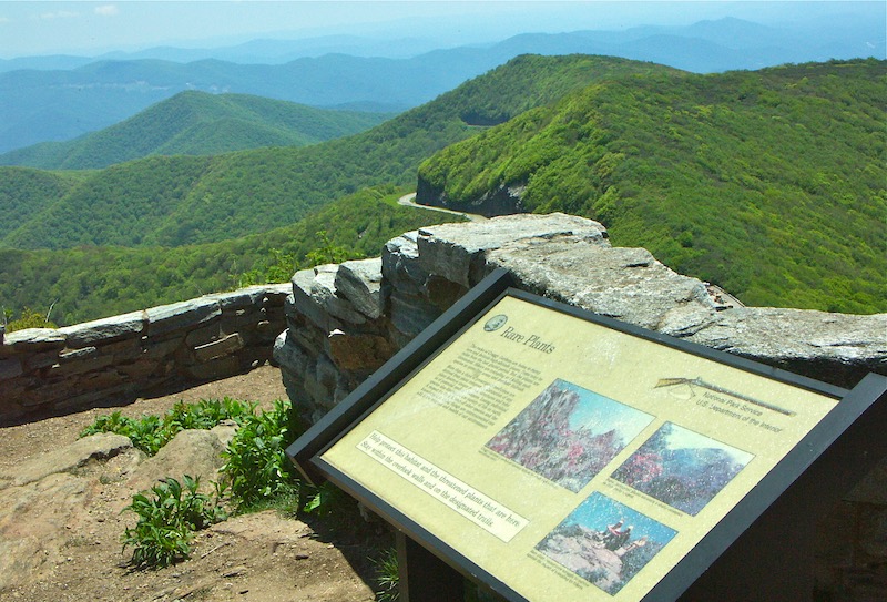 Rare Plants interpretive sign on Craggy Pinnacle, not far north from Asheville, NC, near Mount Mitchell. The stone-walled viewpoint is one of many such historic vista spots from the early days of the Blue Ridge Parkway. The Civilian Conservation Corps built many structures and facilities along the Parkway.
Hiking around Boone, Blowing Rock, Linville, and Banner Elk
In this high-country area, now very widely just called the High Country, there are a few towns: Boone, Blowing Rock, Linville, and Banner Elk. If you’re in any one of those towns and you’re Googling Boone hiking, Blowing Rock hiking, Linville hiking, you’re talking about hiking in the same area.
All of these towns are close to Grandfather Mountain, which sits in the middle.
I live just south of Boone, on the flank of Grandfather Mountain, in the heart of the High Country. It’s cool in the summer, snowy in the winter, with three major ski resorts. Overall, a really neat area. It’s becoming much, much more popular and we do have some folks who want to keep it a secret. I chuckle at bumper stickers that say, “Boone sucks. Tell your friends.”
Boone is similar to but a lot smaller than Asheville. Boone is a major college town, with Appalachian State University, and a growing national reputation in academics and football.
Grandfather Mountain is the kingpin summit. So, when people ask me where to hike near Boone, I’ll send you to Grandfather Mountain. I love that mountain. It has affected my life.
I started the wilderness trail program there back in the 1970s, which reopened the trails at what was then a private travel attraction. A hiker had died from hypothermia, and that had closed the backcountry. Luckily, in the early 2000s, the vast bulk of the mountain was purchased by North Carolina. Today it is public land and a designated state park. Although, a small part of the mountain is still a privately owned attraction run by a stewardship foundation. The state park is known for spectacular alpine climbing across the summit ridge, climbing ladders over cliffs. There are all kinds of other places in the area to hike, but Grandfather Mountain is my favorite.
Blowing Rock has a really historic little downtown that often wins honors for most picturesque small town, which means it can be better to visit in the off season. You can walk right out of downtown Blowing Rock to a trailhead and go all the way down a waterfall-filled chasm. There are wonderful viewpoints on top of waterfalls. It’s a unique thing for a mountain town to have. It’s not a greenway, it’s a real hike, right from your front door.
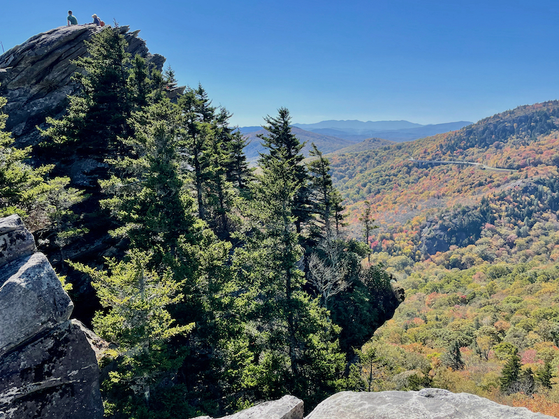 Two people on rocky peak of Rough Ridge with spruce forest and distant autumn color. This is the eastern flank of Grandfather Mountain, showing the arching high-tech span of the Linn Cove Viaduct, a scenic high point of the Blue Ridge Parkway. The Parkway soars across this bridge and in the far distance, the entire ridge of the Black Mountain Range is visible, rippling the horizon—including the East’s highest peak Mount Mitchell among the summits.
Hiking near Hendersonville, Brevard, and Highlands
Hendersonville is south of Asheville, quite close to the South Carolina border. For great hikes in the Hendersonville area, I suggest heading to DuPont State Recreational Forest. It has almost 100 miles of great mountain biking and hiking trails. The trails are often very gradual. There are lot of nice streams to walk along, plus some higher elevation areas with granite domes that you can hike or mountain bike over. DuPont State Forest is really a nice spot, with some of the state’s best waterfalls hikes. That includes Hooker Falls Trail, High Falls Loop, Grassy Creek Falls Trail, and Triple Falls Trail.
Hendersonville and Brevard are on opposite sides of DuPont State Forest. For those strictly interested in hikes near Brevard, set your sights a little farther north in Pisgah National Forest, where Shining Rock Wilderness is.
Highlands is also quite near Brevard and Hendersonville. Looking Glass Rock is a popular hike in the Highlands area. So is Whiteside Mountain. It’s not a very long hike, and you start fairly high up. It takes you across the top of what may be the highest cliffs in eastern America. It’s very popular with climbers.
Hiking near Charlotte, Winston-Salem, and Greensboro
North Carolina’s biggest city is Charlotte, and when you’re in that kind of situation, what do you want to do? You want to get out of dodge.
Luckily, Charlotte is part of a string of cities, including Winston-Salem and Greensboro, that stretch in an arc across this beautiful area called the Piedmont of North Carolina. It’s very verdant, it’s very unique. There are many, beautiful state parks scattered along that arc of cities. Monadnock is a geological term, and it means an isolated mountain standing clear of adjoining mountain ranges. There are a bunch of these monadnocks outside of the cities. These areas are like little mountain ranges in themselves.
Crowder’s Mountain State Park is just a short distance from Charlote. It’s best to go during the week or in the off season. Also near Charlotte is the Uwharrie National Forest. It is a bonafide national forest in the middle of North Carolina. There’s a federally designated wilderness area there called the Birkhead Mountain Wilderness. The Uwharrie Trail there is a long-distance hiking trail. It takes days to backpack this trail, but it’s relatively easy to get to from the city.
Just northwest of Winston-Salem, there’s a mountain called Pilot Mountain with spectacular hiking right near the city. Same with Greensboro, just north is Hanging Rock State Park. This mini mountain range has wonderful, historic facilities built by the Civilian Conservation Corps. It also features rock climbing galore and great hiking.
So, North Carolina is special in that it just drops these neat little mountain state parks beside these big urban areas, surrounded largely by undulating or flat land, except for the mountain parks. So, you can stand on these mountains and see the Blue Ridge to the west standing out like crazy, and you can be up on the Blue Ridge Parkway and look way down and see this one little mountain top, down near Winston-Salem, or you can see Crowder’s Mountain standing out, down near Charlotte.
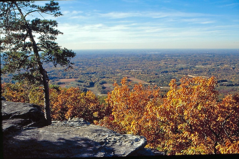 Autumn color clifftop in the central, Piedmont flatlands of North Carolina. Weeks after autumn color has fallen in the mountains, the flatlands of the North Carolina Piedmont are colorful into mid- and late-November—especially when seen from a handful of isolated mountain tops that lie far east of the highest mountains. This summit view in Hanging Rock State Park, is north of and not far from the central NC city of Greensboro. The vista shows the region’s otherwise flat and gently rolling woodlands.
Hiking near Raleigh
For hiking near Raleigh, I recommend Umstead State Park. It’s west of the city, near the North Carolina Museum of Art (which means walks and rides there have a lot of public art). There’s all kinds of hiking and mountain biking trails. Umstead really is a neat little natural enclave.
You can travel to trails to hike, but in the case of the Mountains-to-Sea Trail, it comes to you. This trail stretches across the state, and in Raleigh too. There are wonderful wooded sections where you’re hiking on a natural surface trail. There are also greenway sections, where you can ride a bicycle or jog. On this trail you’ll go right by a really big lake, Falls Lake, and along scenic streams, like the Neuse River. There are an increasing number of greenway trails and sections of the Mountains-to-Sea Trail cropping up in urban areas in North Carolina.
Exploring the Mountains-to-Sea Trail
I have a history with this particular trail. I managed the Grandfather Mountain backcountry around the time the Blue Ridge Parkway was completed across Grandfather’s flank in 1987. In that role, I was instrumental in making the Tanawha Trail, the new path just built along the Parkway, part of the Mountains-to-Sea Trail.
I was an early task force leader helping build the trail back in the 1980s. Today, I am still the task force leader for the Grandfather Mountain part of the Mountains-to-Sea Trail, and I serve on the board of the Friends of the Mountains-to-Sea Trail.
Sections of the MST are still unfinished, in the sense that the final location hasn’t been chosen. However, you can hike the whole trail. Certain sections of it will change later as permanent, formal trails are built. It’s about 1,175 miles from the Great Smokies, all the way to Jockey’s Ridge on the Outer Banks.
A real good way to appreciate the diversity of North Carolina and its hiking trails is to hike the Mountains-to-Sea Trail. It is a true memorable transition through one of America’s great trail states.
The Friends of the Mountains-to-Sea Trail group offers guide books by region: mountains, Piedmont, coast. However, they also offer smaller books, and I believe you can access that information free online, as the trail evolves. They are keeping that extremely up to date.
You know about the Appalachian Trail, and other long trails, that are popular with thru-hikers. But when people want to section hike those trails, sometimes they have to drive far to get to them. The Mountains-to-Sea Trail is different because it actually comes to the people. As the trail expands, it connects cities and neighborhoods across the state.
With everybody fleeing out to nature to get away from the stress of the pandemic, so many people are discovering that the Mountains-to-Sea Trail is nearby, ready to take them on a close-to-home adventure into the natural side of North Carolina. That’s a pretty exciting project to be involved in.
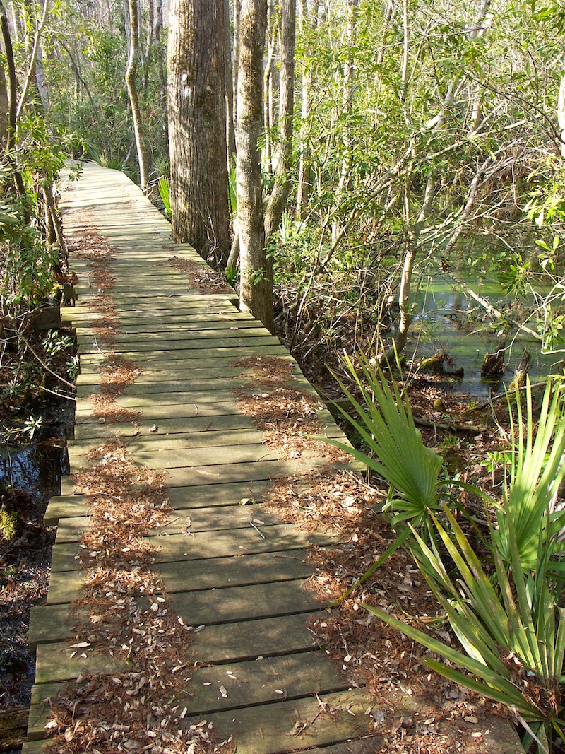 Subtropical vegetation and trail boardwalk of the Neusiok Trail in Croatan National Forest. The Croatan is eastern America’s only coastal national forest. The Neusiok Trail is a multi-night backpacking trip with plentiful greenery, even when it’s cold and snowy in western North Carolina’s high mountains. The Croatan is close to NC’s famous Atlantic beaches including the Cape Hatteras and Cape Lookout National Seashores that protect the state’s Outer Banks barrier islands.
North Carolina’s Hardest Hikes
Boy, oh boy. It depends on how long of a hike you want to take. I mean, there are some extremely rugged short hikes. I’ve hiked a lot of places in New England and out west, and the trails mentioned here could easily be compared with the hardest hikes in other regions.
Grandfather Trail – short hike
You can get pretty tired hiking just 3 miles of the Grandfather Trail across the rocky crest of Grandfather Mountain, especially if you go out and back. Best way to do that is drive to the summit attraction run by the Grandfather Mountain Stewardship Foundation.
This trail is often considered the most technical trail east of the Mississippi. As a result, people have called it “Chutes and Ladders” because of the cable and ladder systems that you’ll use to scale some sheer rock faces. This trail might be short, but it’s best for experienced hikers.
Linville Gorge – long day hike
You know, I would say that you can wear yourself out pretty dramatically descending into the Linville Gorge or hiking along the Linville River, in that chasm, on the Linville Gorge Trail. The total trail length along the river is 11.5 miles, but getting down into it is the hard part because the terrain is very steep.
Linville Gorge Wilderness Area is located in Pisgah National Forest, and is accessible from the Blue Ridge Parkway, approximately 60 miles northeast of Asheville.
Ridge Crest Traverses of the Appalachian Trail – backpacking
If you’re looking for a challenging backpacking trip, traversing the entire summit ridge of Great Smoky Mountains National Park on the Appalachian Trail is at the top of my list. It’s a high elevation ridge walk and it certainly is not easy due to the variation. For example, you can start in the valley below Mount Mitchell, and you’ll be climbing more than 4,000 vertical feet to get to the summit. It’s hard work.
Another must-take ridge hike on the Appalachian Trail traverses the almost alpine summits called balds from Roan Mountain to Hump Mountain in northwestern North Carolina, not far from Grandfather Mountain and the Boone area. Hiking North Carolina really covers both hikes.
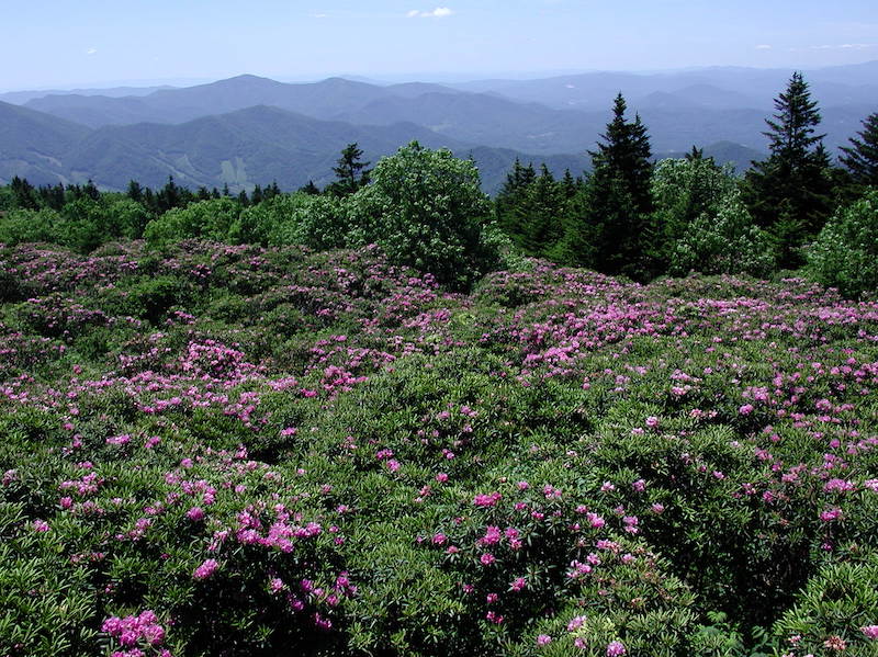 Rhododendron blooms across the crest of Roan Mountain. Surrounded by spruce forest, the rhododendron and sedge grass covered meadows are called “balds” because they resemble alpine areas above timberline. The rhododendron bloom in late June—spring at these elevations. The bloom is one of the Southern Appalachians natural spectacles. The adjacent section of the Appalachian Trail, with miles of open meadow hiking, is one of the famous long-distance trail’s most iconic locations.
Must-Have Books about Hiking in North Carolina
I think some people believe that anybody can write a trail guide, or expect trail guides to be boring. My guidebooks are not dry. I really try to infuse them with a travel writer’s sense of the context for where these hikes are. I also want to provide a bigger picture that helps people decide that North Carolina’s hiking is worthy of a trip and show how it compares to hiking other states in eastern America.
I’ve been a map maker all my life, and that goes back to my trail management days. So, my books include highly accurate maps. Plus, I’m a photojournalist, and have been for a long time. The vast majority of the pictures in my books are shots that I’ve taken myself. I think these attributes help ramp up the quality of my books.
The Best Easy Day Hikes: Blue Ridge Parkway
The Blue Ridge Parkway is a really interesting drive. It’s nearly 500 miles long and offers a unique motoring experience. Not only are there overlooks all along the Parkway, but many of these overlooks are where easy trails start. The Best Easy book is a small volume, and it covers the easiest hikes along the Parkway.
The Blue Ridge Parkway’s entire concept is designed for motorists. Some motorists are sedentary folks, so even they can get out and see spectacular scenery. The majority of trails on the Parkway are considered leg-stretcher trails. Motorists stopping for one of these trails are not going to hike for hours. They’re going to get somewhere dramatic, beautiful, and inspiring even if they’re only walking for 15 or 20 minutes.
So, why did I write a book about the best, easy Parkway hikes? Because there are so many of them, and the very best are just a wonderful invitation to nature, even for folks who are not in great shape. It gives people a different perspective on getting to a trailhead, and perhaps reduces some of the intimidation they might feel.
Hiking The Blue Ridge Parkway
Check Price: REI
I wrote this book because the Parkway is basically a one-stop-shop for an introduction to the beautiful region of the southern Appalachians. This larger book doesn’t just have easy hikes on the Parkway, it has all of the Parkway’s most difficult hikes.
It even directs you off the Parkway to nearby locations where you’re able to sample a broad range of the most spectacular, more difficult, and exciting hikes of the southern Appalachians. You’ll learn about hikes in the nearby national forests, other national parks, and state parks.
If you’re interested in just the western part of the state, Asheville, or exploring the Blue Ridge Parkway, Hiking the Blue Ridge Parkway might be the best book for you. It’s more tailored to that particular region—and that includes the Blue Ridge in Virginia. The Parkway links Great Smokies and Shenandoah national parks.
Best Easy Day Hikes Great Smoky Mountains National Park
The pandemic has really brought higher visitation rates to parks into stark relief. Trails around the country are swamped. So many of them are so popular that, you almost can’t even socially distance safely.
I’m sensitive to overcrowding, and with my books I try to encourage getting out on trails that are less crowded. I want people to have a good experience.
Sometimes the hikes listed are popular. Let’s face it; you have to visit the popular spot sometimes, right? People flock to those trails and vistas because there’s something worth seeing. What I often do is recommend a less-frequented starting point in the directions. It will take you to the scenic spot that everybody else is looking at, but it’ll get you there on a quieter trail. You might stand at the viewpoint with a bunch of folks, but the minute you go back down the trail, you’re alone again. I take the same approach in Best Easy Day Hikes: Blue Ridge Parkway.
Hiking North Carolina: A Guide to More Than 500 of North Carolina’s Greatest Hiking Trails
I’ve been tracking my love of the state and hiking trails across NC for many years. This book is an excellent example of why writing a guidebook isn’t necessarily easy. This was a serious undertaking, with a ton of exploration accumulated over time. The book just came out in a fourth edition.
There’s always something new to discover. I think the thing I realize every time I update this book is that North Carolina has the most diverse terrain and climate of any state in the eastern U.S. North Carolina goes all the way from mountains near 7,000ft, in the western part of the state; across the Piedmont; all the way to the coast and even offshore along barrier islands.
You can have everything from sub-alpine peaks that get more than 100 annual inches of snowfall and are almost above tree line, all the way down to the opposite end of the state where it’s subtropical. The vegetation change is so dramatic. Somebody can be cross country skiing in northwestern North Carolina, and the same day somebody else can be hiking along a sandy trail in the Outer Banks, and it’s 60-70 degrees. North Carolina is extremely diverse, and that’s the point of putting a book like this together. There are so many quintessential experiences scattered across this surprisingly lengthy state.
Fun to note, just last spring, Hiking North Carolina won a bronze award in the travel book/guide category of the North American Travel Journalists Association contest. I think an award like that reflects that people appreciate a deeper, personal perspective along with a lot of detail.
Hiking North Carolina is for the person who’s interested in a range of hiking across the state. It does have sections for Asheville and a lot of information about the Blue Ridge Parkway. However, for the person living in Charlotte or Raleigh, and heading west, or east, to hike, this is the book for you.
Grandfather Mountain: The History and Guide to an Appalachian Icon
I love snow and cold. When I was in graduate school in Virginia, I set out to find the coldest, snowiest, most spectacular mountain in the south. I discovered Grandfather Mountain. And lo and behold, the mountain that I love turns out to be, perhaps, the most iconic mountain in the Southeast.
The Nature Conservancy has called Grandfather Mountain the most ecologically significant mountain in all of eastern America. This mountain epitomized everything I love, and it just so happens that mountain is a figurehead, no pun intended. It’s named Grandfather because there’s a profile face on the mountain that looks like an old man.
I fell in love with Grandfather Mountain and moved nearby when I discovered that the mountain’s hiking trail system. It had been built back in the 1940s, was so overgrown that people had died up there. People were getting lost and dying of hypothermia.
This mountain was privately owned, and he closed the mountain, put up “no trespassing” signs to deter hiker deaths and other problems. I didn’t want that to happen, so with my research and experience in backcountry recreation management, I persuaded the owner, a public-spirited, well-known North Carolinian named Hugh Morton, that I could manage Grandfather Mountain and keep hikers safe. My goal was to keep it open to the public, and to keep it safe for the owner and all the people who came to enjoy the mountain. So, he hired me to do that.
I’ve spent a lot of years here, and conducted a lot of research on what I truly think is one of the most special mountains in all of eastern America. The book is basically the broad history of the High Country and the Appalachians told through the eyes of the true “Old Man” of the mountains.
Southern Snow: The New Guide to Winter Sports from Maryland to the Southern Appalachia
Check Price: Amazon
This one is a bit different than the others. It really speaks to all the downhill skiing, cross-country skiing, and winter mountaineering you can do in the south. The book recently won an award from the International Ski History Association for the way it tells the remarkable, nationally significant story of skiing in the south.
One chapter in the book is about the climate of the southern snow belt. The National Oceanic and Atmospheric Administration called it the definitive study of southern Appalachian weather. So, for those interested in the snowy side of North Carolina and the south in general, this book is going to interest you. Ski film pioneer Warren Miller called the original 1987 book “a cult classic.” Thirty-five years later it’s out again, the complete guide to the region that teaches more people to ski than any other!
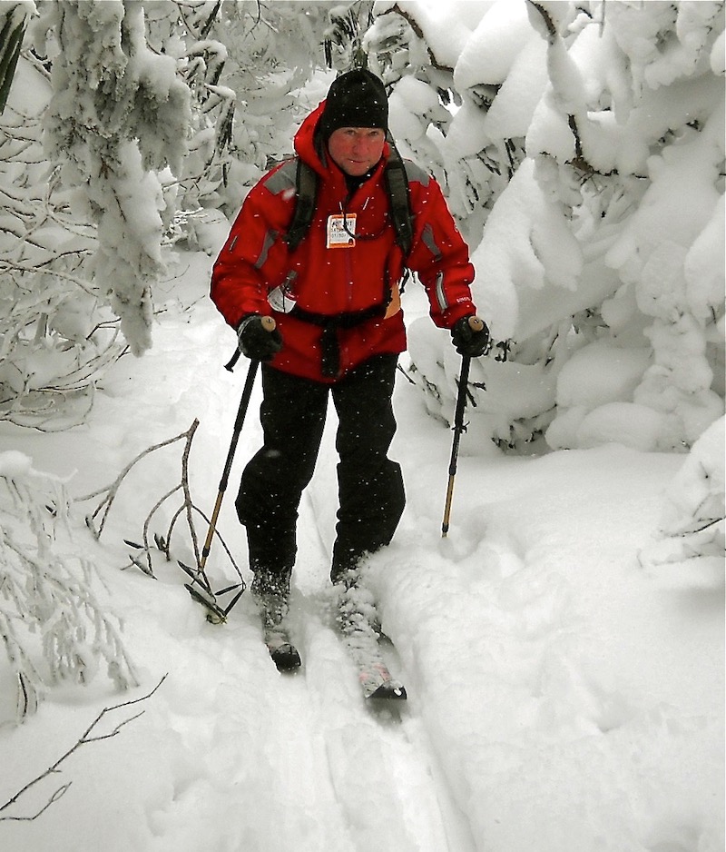 Randy Johnson skiing the Appalachian Trail on Roan Mountain, North Carolina. Roan Mountain is 6,300 feet and receives more than 130 inches of snow annually, more than Buffalo, New York. The mountain’s spruce and fir forests are a great example of the Canadian zone ecosystem. Renowned naturalist Asa Gray called Roan “the most beautiful mountain east of the Rockies.”
North Carolina’s Hiking Trail Quality
North Carolina is increasingly attracting an outdoorsy demographic. Folks come here because of what we’ve got, and a lot of these people are really volunteer oriented. They care. North Carolina has some pretty impressive trail construction companies. They’re getting grants and national park and forest money to build new trails and improve old ones. So, there is a lot going on.
There’s a lot of multi-use trail development in North Carolina, especially given the explosion of mountain biking, so there’s a lot of mixed use on the trails. Notable example for cyclists is the town of Cary, near Raleigh. It’s the biggest town in North Carolina, and it has an extensive greenway system and is very bike friendly. You can ride your bicycle from anywhere in town to a nice mountain bike trail network near Lake Crabtree County Park.
Mountain trails are especially challenged by climate. The highest southern Appalachians are basically a temperate rainforest, and the highest peaks are very damp, very similar to hiking in the Pacific Northwest. There can be a lot of water on the trails. As a result, a lot of time is spent preventing trail erosion.
Top Safety Tips for Hiking in North Carolina
When it comes to hiking in a new place, it could be easy to fall back on the tried-and-true notion to “just be smart,” but I’ll go a little deeper.
1. Because North Carolina is so diverse, people forget the risks associated with any given region. For example, people have died of hypothermia in the high mountains of North Carolina. Maybe they didn’t do their research, or they made an assumption about the state as a whole. The same can be said for the coast, where people are surprised by triple-digit temperatures and 100% humidity. Just do your due diligence and plan accordingly for the weather where you’re headed.
2. I would say, never hike alone. Definitely not. Be smart, have all the water you need, have the right shoes on, be prepared clothing wise, food wise, for the worst conditions that you might encounter.
3. If you are hiking alone, make sure somebody knows your plan. Here are the basics to share with your contact:
- The trail head you’re parking at
- The trail you’re planning to hike
- How far you plan to go
- What time you plan to return
- Confirm that you will check in with them
When you do get back to your car or into a service area, call them. All of that is just super important.
4. When headed somewhere that requires a permit, get one. Permits are used to control the number of people on sensitive trails. Being aware of and complying with permits is very important. However, if you are hiking solo, permits mean someone knows approximately where you are. In the event that you don’t check in with your friends or family, the authorities will have an idea of where to look for you.
A state like North Carolina can throw a lot of different things at you and surprise you. Read about where you’re going; know about where you’re going. Have a map. Don’t just rely on a cell phone GPS, because you could end up in a no-service zone or your battery could die. Plus, the more you know about where you’re going, the more you can decide not to go to the busiest parking area, the most crowded spot, the worst section of trail, and the more you’re able to scope out an alternative way to get to where you want to go.
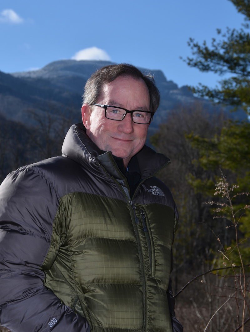 Randy Johnson poses with Grandfather Mountain behind, near Boone NC. The summit seen is Grandfather’s highest 5,946 foot Calloway Peak. Taken in the Watauga River valley below the peak, near Foscoe, North Carolina, postal location of Banner Elk, North Carolina.
A Bit About Randy Johnson
These days I’m focused on articles about travel and outdoor recreation, updating/expanding my established hiking guides, and writing a few recent books that I’m really passionate about. It really all grew out of my interest in wilderness management. There are a lot of people out there who want to be working outdoors, living that outdoor lifestyle. I gravitated to what was most interesting to me, which is how to manage the people who are out in wilderness. The goal is to preserve wild spaces and keep people safe.
When my books recommend starting a hike at an alternative spot that’s not as popular, I’m being a trail manager. I suggest starting on a trail that’s not quite so impacted by human use. Or, I suggest how to avoid the problematic, crowded experiences parks struggle with. My books help people feel prepared so they’re not getting lost, and point out older trails or hazards to avoid. I’ll include specific details for how to get around them.
I’ve always wanted to be involved in supporting good outcomes for wilderness and for trails. Today I do that in my books, but it started a long time ago. I’ve been doing it ever since I did research with the Forest Service and Appalachian Mountain Club, and helped keep the trails of Grandfather Mountain open 40-some years ago.
Carola Jain
North Carolina definitely seems to have its fair number of places where one can hike, but anyone looking to hike should be prepared. Knowing what to pack, how long one will be out, and the like will be important.
Martha Misenheimer
This author has an amazing range of experience with NC trails and natural areas! I really enjoyed his story of working with Hugh Morton, a superstar of preservation. One small detail to point out is that Mt. Mitchell would not be included in a GSMNP ridge hike. I look forward to buying Randy’s trail guides-thank you!
Randy Johnson
Marcus, thanks for helping me share my love of hiking in North Carolina! Just FYI, the brand new fourth editions of Hiking the Blue Ridge Parkway and Best Easy Day Hikes Blue Ridge Parkway have just come out in late 2022.
Marcus Shapiro
Thanks for checking back in Randy. I updated the links above. Great work as always!
Jet
Awesome article! Which one do you recommend for beginners? Specifically, someone who has zero experience hiking?
Randy Johnson
Thanks for asking Jet. The easy answer is try any easiest rated hikes in my books. Since those kinds of hikes are all over NC you’ll need to determine where you want to go, or where you are, and choose the book that covers that area. That said, and to get deeper into the topic of how I can help you stay safe as a never-ever hiker, be aware that besides a trail being very gradual and graded (smooth with stable footing), trails that are aimed at beginners are often located where the trails are easy to follow and intended for a beginner user group. Top ideas that come to mind—the Blue Ridge Parkway. These trails are designed to serve motorists on the Parkway, often largely sedentary people with little trail experience, so these easy paths are simply called “leg-stretcher” trails. You’ll be safe and enriched just stretching your legs on the Parkway’s easy paths. Or any easy trail, especially if they are designated as a TRACK Trail, a program of the Blue Ridge Parkway Foundation that provides guided brochures with maps at trailheads that educate and entertain families as a target group (they can also be downloaded from the Internet). These paths are all over the Parkway and increasingly North Carolina. My books point out these paths. Good luck, and Hiking NC and Hiking the BRP also have detailed introductions that’ll go a long way toward being sure you’re prepared with the right gear and knowing what to expect. Get out there!!
Kelley Horm
Emily and Marcus,
North Carolina has so many beautiful opportunities for hiking! I hope to soon make the trip to the NC mountains for a hike. As someone who lives far from the mountains, I am excited to see there are many hikes in the local cities as well. Do you have any recommendations for someone who is hiking with a dog? I am eager to get out on the trails!
Thank you for sharing your wealth of knowledge!
Marcus Shapiro
Appreciate the feedback. Check out AllTrails to discover dog friendly trails.