Almost Everything You Need to Know about Hiking Mt St. Helens
With 17,000 miles of hiking and backpacking under his belt, wilderness guide and ultra-light backpacker Erik Soltan of Get Out Backpacking joined the Fit For Trips team to speak about hiking Mount St. Helens. He dove right into to tell us what he loves about it and provides insight on almost everything you need to know about summiting and hiking around Mt St. Helens.
This volcanic peak, located in southern Washington state in the Cascade Range, is a hiker’s playground. It is home to trails of varying distances, making it a destination for everyone from visiting families, to day hikers, to backcountry enthusiasts. Visitors can enjoy the lush greenery typical to the Pacific Northwest, grand views of neighboring Cascade peaks, and the stripped landscape of the blast zone from the 1980 eruption.
If you do plan to head to Mount St. Helens for an epic hiking trip, know that the terrain can be tough on the body, so some training can help get you ready to tackle the trails. Check out Fit For Trips’ custom training programs or schedule a complimentary fitness consultation with Marcus Shapiro.
What are the Cascades?
The Cascade Range is part of the Ring of Fire. The Ring of Fire rims around the Pacific Ocean. So, Cascade Range stretches from northern California, through the Pacific Northwest, and up into Canada’s British Columbia.
Within the Cascade Range are the High Cascades, or the volcanic peaks. Mount Baker is the furthest north, and the furthest south is Mount Lassen in Northern California.
Of course, you have peaks and wilderness areas in between these volcanic mountains, such as the Dark Divide, the largest roadless area in western Washington, and Mt. Rainier, plus some of the other areas north of Mount St. Helens that are nice to explore.
What do you love about hiking Mt St. Helens?
The diversity you see there is just unbelievable between the old growth forests and the blast zone, which has very few trees left on it. Despite this, things are growing. To see the mountain coming back, it’s what I imagine hiking in the desert would look like. If you’re one of those people that likes to see the bleak beauty of things, with wildflowers coming up through the sand or pumice, it can be really inspiring.
Hiking along Mount St. Helens you see the bits of purple and red from the Indian Paintbrush, lots of mountain goats, and all the fresh springs have little bits of moss and green in them because it’s the northwest and it gets a lot of precipitation. The colors are outrageous against the background of a landscape where everything has been stripped away.
I’ve hiked all around High Cascades with trails, and I feel like Mount St. Helens has more of a fiery history. You’ll see evidence of eruptions throughout time, not just from the 80s eruption, on all the sides of the mountains. As the mountain rebuilds it’s amazing to see the freshness of life coming back.
It’s interesting that a lot of animals like pika and marmot have such a history on this mountain. Obviously, the animals living there today haven’t lived through an eruption, but in 1980 a lot of animals sensed something coming and went underground when the landslides came through after the eruption. When it cooled down, a lot of those animals popped back out, which is also very interesting to think that, instinctively, in that area, they knew that something was going on.
Also interesting; in the 70s, the people of the Klickitat tribe were telling local scientists that there was a problem with the mountain. They noticed the northern face of the mountain was slumping and interpreted it to be upset and angry. In nearby Spirit Lake, ripples in the lake were noticable despite the absence of wind. In hindsight, it turns out the ripples were caused by earthquakes and underground volcanic activity.
The Klickitat had moved their tribe around different parts of Mt St. Helens based on where they could find food, stuff to trade with other tribes, and because of the unpredictable volcanic activity. There are Klickitat legends to keep other tribes and people away from the northern side of the mountain because of its fiery past.
What is your favorite Mount St. Helens Hike?
I’ve hiked all the ’round-the-mountain trails in the Cascades and each one is special to me. I do love the Loowit Trail going around Mount St. Helens. I’ll go into more detail about the Loowit Trail later, but my reason for loving it is for all the diversity; the landscape variety, the flora, and the animals you see along the way. It’s wild.
I hike because I get what I call “exposure” from it. The longer I’m out in those more isolated areas, the more I come back feeling like a clean slate. I wish a lot of people could enjoy that. I think our world would be in a lot better place if people could get away from the pressures of society.
Let’s face it, the world is very complex right now. When all you’re doing is walking and eating and moving, getting yourself from point A to point B, it’s a lot easier to allow your brain to relax, and it can happen for days or weeks on end. It gives you a sense of relaxation.
The one thing I don’t like about climbing Mt St. Helens, as opposed to trekking around it, is that you’re surrounded by people the whole time. At the top, it’s like being in a mall, and then you slide down and then you’re done. I don’t like that about day hiking, in general.
I don’t day hike too often. By the time you get everything ready, get your pack ready, drive out there, you hike, and you come back, you’re just in traffic again. I feel like it counterbalances any relaxation that you would have gotten, exposure-wise, from being in nature.
Going around Mount St. Helens is great because there are only a few places you can enter the trail. A lot of other roads are really hard to get to or have been washed away, so you don’t see a lot of people on those other parts of the mountain because of the effort it takes to get there in the first place. It gives you a more personal experience with the mountain.
The Loowit Trail was named after Princess Loowit, of native legend. Loowit was the native name for this symmetrical, conical mountain, which eventually came to be known as Mt St. Helens. It’s the only Cascade peak which the Native Americans believe was of feminine origin. When you’re hiking on the Loowit Trail you can almost see the curvature of the conical shape the natives saw. It’s just really a beautiful mountain to see, especially from that shape perspective.
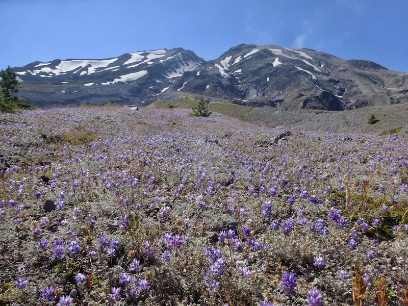 Checking out lupine flowers on the east side of Loowit Trail. Mount St. Helens in background.
What’s the difference between hiking around and summiting Mount St. Helens?
They’re very different, but each has their merits. It really depends on the experience you want to have. Do you want to day-hike or backcountry camp? For views, do you want the view from the top, or do you want to experience all of the different parts of the mountain? Do you want the safety of other nearby hikers or the solitude of remote wilderness?
Summiting Mount St. Helens
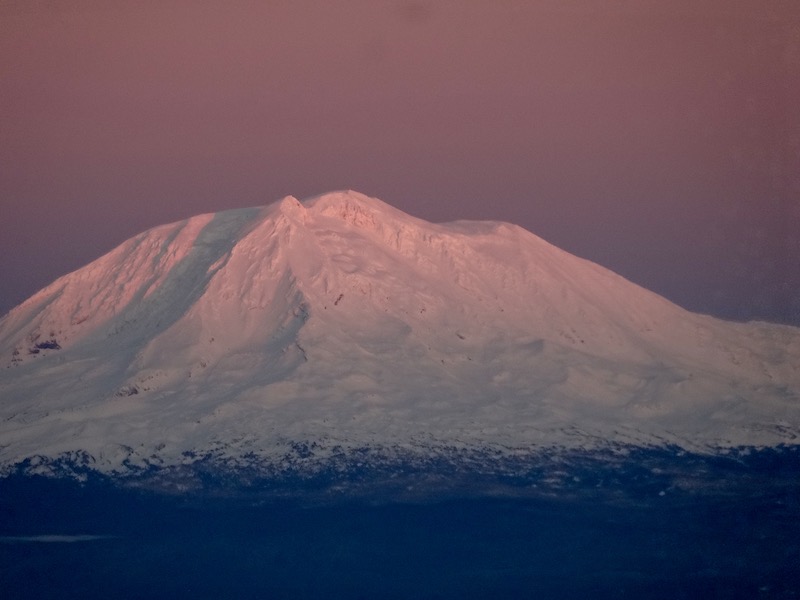 View of Mount Adams to the east from summit of Mount St. Helens. Pinkish effect is called alpenglow.
When summiting Mt St. Helens, you usually start at a low trailhead. There’s a winter route (Worm Flows from Marble Mountain Sno-Park) and a summer route (Monitor Ridge from Climber’s Bivouac). When you climb up to the summit, which stands at 8,363ft, you’re able to see inside the caldera and the breach where the mountain blew out on the north side during the 1980 eruption. This isn’t a technical climb, but it still takes effort.
Scenery
Mount St. Helens doesn’t have glaciers to trek over, so you don’t really see a lot until you get to the top. Of course, when you see inside the caldera from the summit it’s phenomenal, especially the rate it’s growing at. To see all the trees are stripped away in the blast zone is also amazing, too, because there used to be a lot of old growth on the north side before it blew out. To picture what that was like beforehand is really interesting and inspiring, for sure.
Terrain
On the way back to the trailhead you can slide down through the snow, which is called glissading. You would typically use an ice axe to slow you down. So, it’s all effort on the way up and then sliding down is obviously fun, but it can get out of control sometimes with the speed, especially if it gets icy. But, for the most part, it’s pretty safe.
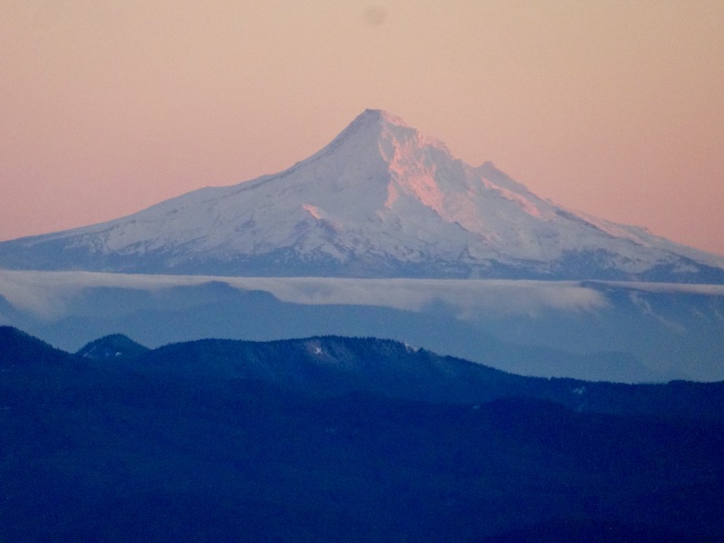 Mt. Hood viewed from Mount St. Helens, with lake inversion effect visible horizontally in the center.
Hiking Around Mount St. Helens
Trekking the Loowit Trail around Mount St. Helens is 34 miles, and it’s typically spread out over a few days. It’s hard to say exactly how long the trail is now. It has been rerouted several times due to the soft pumice that slowly gets destroyed by the rivers. So, it used to be 30 miles, but these days it’s probably more like 34 or 35 miles. I’d recommend at least four days for a novice hiker to enjoy the experience.
Scenery
I think going around is better because you learn a lot more about the mountain. You’ll hike through old-growth forests, there’s a lake, you’ll hike through the blast zone, and you can see inside the caldera from a different vantage point. You get to see waterfalls pouring from the glacier inside of the mountain, too.
The glacier inside the caldera is the only one in North America that is growing, whereas all other glaciers on the continent are receding. This glacier is stuck inside that crater and shaded by rockfall and pumice, so it doesn’t get a lot of sun. Interestingly enough, because Mount St. Helens is an active volcano, the heat from underneath is causing the glacier to slowly melt and move outside of the breach area. You can actually see where it’s moving, it’s kind of cool.
Elevation
As far as elevation gain and loss, hiking around Mount St. Helens easier than some of the other peaks in the Cascades. For example, Mount Rainier’s Wonderland Trail is 93 miles long and has 36,000ft elevation gain. In comparison, Mount St. Helens probably has something like 8,000-9,000ft of elevation gain over those 30-something miles. So, you’re hiking on flat terrain more than going in and out of ravines. The highest point on Loowit Trail is around 4,800ft.
 View of Toutle River from Loowit Trail.
Difficulty Level
In some ways hiking around is easier than summiting, but in others it’s more difficult. Hiking in the soft pumice is hard because every step feels like you’re taking two. I always climbed in winter because it was easier for me to use snowshoes or traction devices to get a foothold rather than constantly digging into the sand. Imagine hiking across a sandy beach if it were all dunes. It would be really difficult because you’re sinking in constantly.
Backcountry Camping
Going around, you’ll have to camp. I always hike it counterclockwise, starting over at the Climber’s Bivouac, where you go through the old growth first. You will hit a 10-mile stretch in the blast zone between Windy Pass and the Toutle River’s South Fork on the north side of the mountain where you’ll have to push through in one day. It’s illegal to camp in there, and there is ongoing scientific research happening in that area. That adds an element of complexity when planning.
I recommend camping in the Pumice Butte area on the west side of the mountain, before the blast zone. It’s flat, you get a little protection from Pumice Butte, and there’s a shelf that you can camp underneath. You’ve got a glacial stream coming in there that is okay to get water from, but there’s a spring that’s a little further along that has really, really good water. Honestly, it’s some of the best on the mountain. You’ll want to load up before hiking through the blast zone.
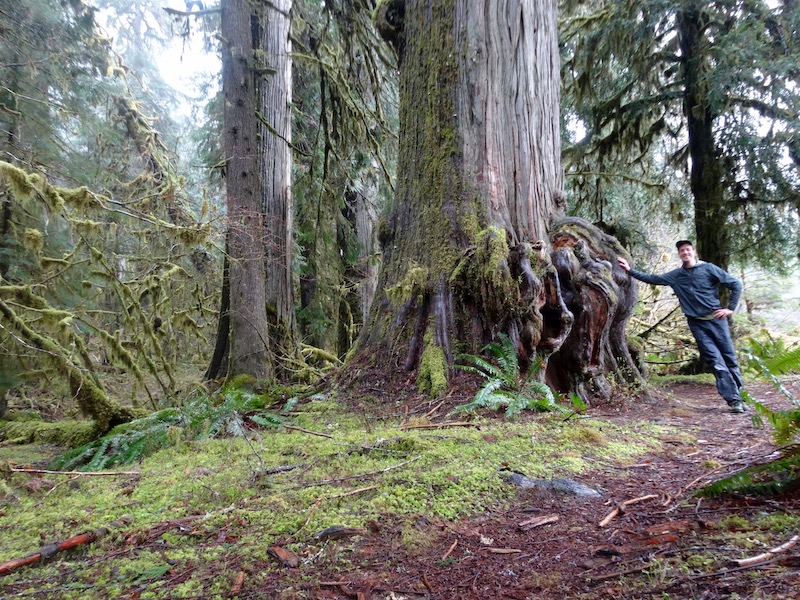 Erik holding up Western Red Cedar tree located on the Lewis River Trail in Gifford Pinchot Wilderness area. This is an example of old growth which is what it used to look like before eruption.
Exposure and Terrain
You’ll go through these lava fields that are really tough on your sneakers and sometimes even your body. Because it’s wide open, the sun exposure is inevitable. In those barren areas, since there are so few trees coming through the lava rock, there isn’t much shade. You’ve got to bring a lot of sunscreen.
The terrain around Mount St. Helens makes it difficult to get your footing. During eruptions, the mountain threw down these things called lava bombs. They are huge rocks that landed and burst apart, causing the shards to be at different angles. It takes a lot of physical and mental energy walking through the sandy pumice and sharp rocks.
Trail Conditions
To navigate, you follow these wooden poles placed along sections of the trail. Those markers get decimated due to wind, winter conditions, and volcanic activity. Since Mount St. Helens is still a national monument and doesn’t get a lot of funding in this day and age, repairs aren’t made every season. So, when you’re hiking through the lava fields, sometimes you can’t see where those wooden poles are around the protruding rocks and you have to do a little bit of route finding.
Top tips for Mt St. Helens hikers
Definitely have your gear on lock. You don’t want to be on Mount St. Helens, or any trail, unprepared.
One thing I’d recommend bringing are hiking poles. I don’t want to say they’re essential, but I think for long distance hiking, I think they are. In this terrain—with river crossings, going down those steep pumice slopes where everything is moving, the big rocks, the little rocks—the poles function as two extra feet, giving you more contact with the ground. Plus, when you get really tired at the end of a long day, you can use your arms a little bit more than your legs.
Also, from a mental perspective, everything moving underfoot all the time gets tiring. It may not seem like it’s much to be aware of, and it may not be a deadly situation, but it still takes a mental toll. By the end of the day, you’ll be a lot more relaxed using hiking poles. I’m a big, big lover of hiking poles, for sure. I recommend using the basket attachments for the lava fields.
I also recommend using the lightest gear you possibly can. Because of the effort and energy you will expend on the trail, being weighed down by heavy gear is going to make it feel even harder.
Be comfortable with route finding and tough footing. Some spots that are better marked, and some are tougher to follow. When hiking around rather than summiting, you’ll encounter many ravines. You’ll hear the river down below, and a lot of times, the trail on the very top portion of it will be missing. Maybe like, between 20 and 40 feet of it, because the river has carved its way through the soft pumice.
They put ropes in certain places so you can get down these things, but the rocks you’re walking on are moving because they’re sitting in unstable pumice. It’s hard because you need to watch what you’re doing all the time. As you’re approaching rivers in ravines, I recommend taking them a little bit slow. For safety, you just can’t go plowing down the hills.
Know where the water sources are and the condition of the water. For example, water sources coming off the glacier are very silty due to the pumice from volcanic eruptions. That soft powder will clog up and destroy your filter. I recommend using an internal filter that attaches right to your water bladder, or Sawyer Squeeze Water Filter system.
Also, you’ve got to be aware of the water sources that will be available to you, especially for camping, because you need cooking water at night and water to drink for the next day.
Make sure you bring a good map. I use Green Trails Maps—they’re the best I’ve found for the Pacific Northwest. They offer close-up angles of the routes so you can see all the details on the mountain and get an idea of what’s ahead.
Best time of year to hike Mount St. Helens
Early spring can be rough because it’s hard to know what the conditions will be on the northern slopes. It can be a sheet of ice, or it can be pretty clear.
In June and July you’re likely to encounter huge swarms of bugs thanks to the high level of moisture in the Pacific Northwest, but in August they start easing up.
I would say if it’s a light snow year, the end of June is ideal for hiking Mount St. Helens. Or, if snow is average that year, just be prepared for hellish river crossings and to hike through snow patches. You’ve got to be good at route finding in snow, for sure.
I’ve also done the Loowit Trail a few times in September and early October, but with climate changes year to year, going in fall can be a bit trickier. In recent years, the trail has been inaccessible in October with earlier and more snow storms hitting the area.
Parking to access Mt St. Helens
For climbing, you’re usually accessing the trails from approximately the same area, but the summer and winter trails have different parking lots and trailheads. The summer trail on Monitor Ridge has a lot near Climber’s Bivouac and starts a little higher up on the mountain. That access road gets closed in winter, so the winter trail starts slightly lower on the mountain at Marble Mountain Sno-Park, and it’s a longer hike in terms of distance and also time because you have to hike through the snow.
To access the Loowit Trail, I believe there are five different trailheads, which is cool because there are huge stretches where there aren’t any trailheads. It’s just going to be you hiking that area because there’s no really way to leap around between trailheads. This gives you a kind of personal experience with the mountain because you’re not going to be seeing as many people out there.
It’s important to note that roads can wash out. You should always check the Forest Service or Mount St. Helens Institute websites for updates on which roads and trailheads you can access during different times of year.
Hiking Mount St. Helens with dogs
Pets are not permitted at all recreation sites and trails within the Monument Backcountry area. Pets are permitted only in designated pet areas like the Dark Divide and other areas in the Gifford Pinchot and must be on a leash.
If your dog is hearty and you’ve already been hiking with them, I think they can do it. Just know that the volcanic ash and rocks in the lava fields might tear up the pads of their feet. It’s not a bad idea to bring durable paw protection for the lava fields. I know they’re expensive, but it’s better than injuring your dog.
I recommend buying two sets. Have one set for hiking and one for inside your tent. A lot of lightweight tent materials can’t handle a dog’s claws.
Do I need a park pass for Mount St. Helens?
You will need the Northwest Forest Pass to access the forest land where Mount St. Helens is located. The most up-to-date information can be found on the Forest Service website.
Additional information about pass types and winter passes can be found at WTA.org.
Permits to summit Mount St. Helens
You will need a climbing permit to summit Mt St. Helens year-round. April 1 to October 31 you get it from Recreation.gov and they are limited to a certain number of climbers per day to reduce traffic and protect the natural features and ecosystem. It’s best to check Recreation.gov for the most up-to-date information about day-use and transaction fees.
November 1 to March 31 they’re self-issued at the trailhead, free of charge, and there is no limit to the number of hikers. Although, the trails are naturally less busy in the off season.
I also want to plug that the Mount St. Helens Institute leads guided hikes into the crater. I’ve never done it, but I’m sure that’s amazing going inside and seeing the huge walls and all the activity and the new caldera growing. They don’t go in there super deep, but it’ll go in there enough and you can go into areas that you wouldn’t ordinarily be allowed to go into. And obviously, with the scientists who accompany the group, they’ll give you a good perspective on what happened back in the 80s.
Easy Mount St. Helens hikes
There’s a lot of variety in the trails that people can enjoy in the area. These are a few of my favorite hikes that are on the easier side and offer spectacular views.
Planes of Abraham
This area is on the north side of the mountain with excellent views of the inside of the crater, the blast zone, and Loowit Falls, which is a waterfall coming off that new glacier that’s on the inside of the crater and the growing caldera.
June Lake
This spot is accessible from the other side of the mountain, along the climbing route. Volcanic activity created that lake by rerouting the river into this basin of sorts, and there’s a waterfall going into it. It’s a nice camping spot, and it’s a good, easy hike without too much elevation gain. Just a good place to chill out, actually. From there you can walk up higher into a blast area and get good views of the mountain from that angle.
Ape Canyon
On the south-east side of Mount St. Helens, mudflow came through and carved a structure resembling a slot canyon. There’s also an attraction called Ape Caves, which are lava tunnels that people can walk into. To see what lava can do, carving its way around the earth, it’s awesome. It’s almost like you’re in prehistoric times.
Challenging Mount St. Helens hikes
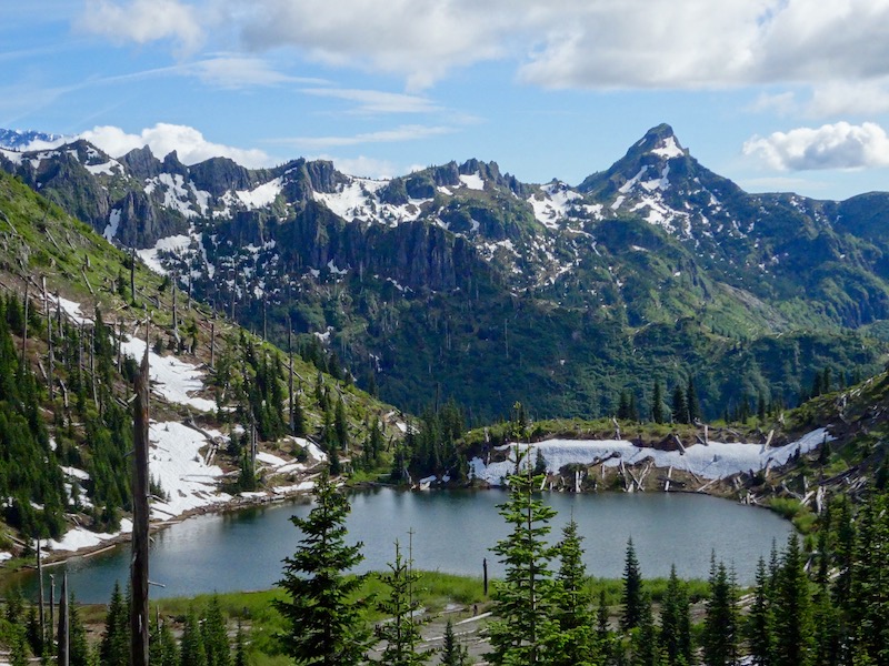
The Mount Margaret backcountry is an area in the northern part of the park forest that has some excellent, tougher hikes. Water is in short supply, so go prepared. You can head up to Norway Pass and then up Bear Pass and drop down into the lakes basin on the other side. You will need a permit to be over there. It’s part of Gifford Pinchot National Forest. It’s a really good idea to hang your food in this area.
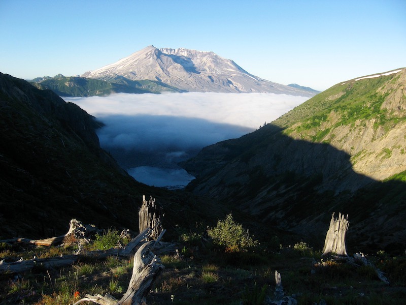 Beautiful view of Mount St. Helens from Norway Pass. Standing at top of spill zone. Spirit Lake below topped with clouds from inversion effect.
Because it’s on the north side of the mountain, as all that hot ash and air from the 80s eruption blew over the Mount Margaret backcountry, it stripped the landscape of all the trees. Since the lakes are all in these different basins, the wind tunneled different ways and pushed the trees down in different directions. So, you’ll hike by one lake and all the trees will be pushed over one way, and then you go to another lake and they’re all pushed another way, kind of like a pattern. For an artsy person, to see those textures is just awesome.
 Snow Lake in Mt. Margaret Backcountry. Behind ridgeline in background is Mount St. Helens.
The Caldera
From the ridge on Mount Margaret there are two nearby camps where you can look into the caldera and see all the action that’s going on in there. A lot of times you can hear a rock fall. But just looking at the mountain from that angle is really cool. There you will see trees that almost look like a giant smashed them in the side of the cliff. They’re completely uprooted from the ground, and you can see bits of wood stuck in the rock and realize you’re witnessing the sheer power of nature.
Spirit Lake
In the Mount Margaret wilderness, you can look down into Spirit Lake, which is where a lot of that activity in the main flow went and was where the biggest landslide in history took place. It came through and pushed Spirit Lake out of its basin, all the way up to Norway Pass. It was an old growth lake, and as the landslide pushed all those really, really old Douglas firs and cedars up the side of that slope, it ended up dragging them back into the lake to settle. Now they’re floating in Spirit Lake in these clusters that look like islands.
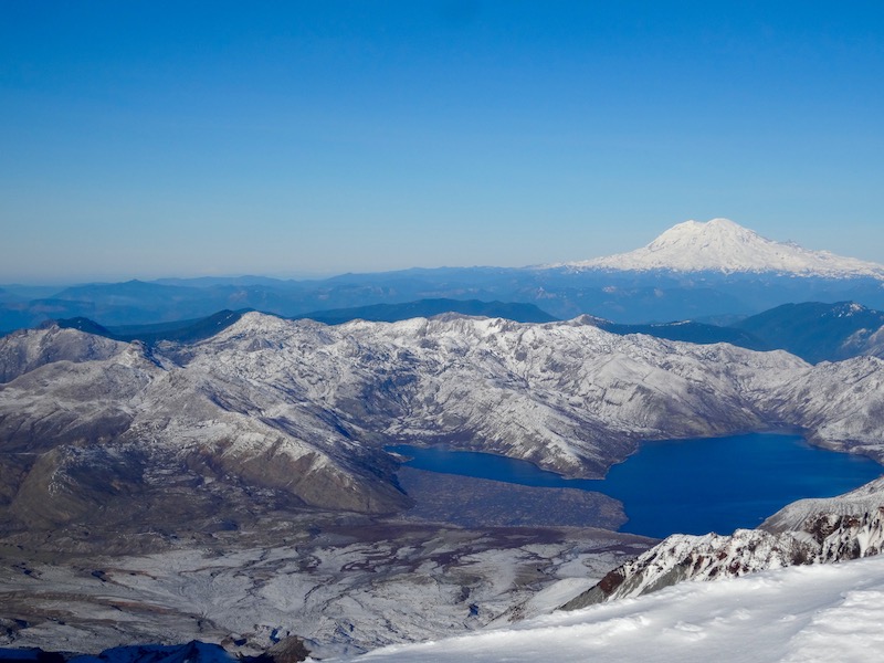 Mount Rainier in back and Spirit Lake in foreground looking from Mount St. Helens summit. In the lake you can see all of the trees floating caused by 1980 eruption.
St. Helens Lake
St. Helens Lake is a little less blasted, but it still has the same islands of floating trees in it. You’ll see St. Helens Lake, which is a really beautiful, deep blue lake, and then Spirit Lake underneath and you can kind of see the line of fire where that volcanic stuff came through. The contrast between the volcanic damage and the surrounding, lush green is really interesting.
Generally, Mt St. Helens is all about the bleak beauty. As the mountain starts coming back and animals are returning it just gets more and more amazing. I’ve seen little bits of trees that look like people have planted them. These little saplings that are spaced just-so distance apart, they’re just rebuilding the forest, and just seeing it come back is really inspiring.
If you’re in a good frame of mind and you’re one of those people that looks at things positively, like the glass is half full, a place like Mount St. Helens is really inspiring because it will rejuvenate your spirits and make you feel good about this world. To see a place that’s coming alive after destruction and coming back so beautiful, it’s just awesome.
Dave Hill
Iam a 56 male who took a 800 ft tumble down St Helens back in the Mid 90s, before social media and I lived to tell about it so now Iam going back next July to finish what I started, after 12 major Surgerys, being Homeless for 4 years from 2016 to 2020 I hope to make it a pretty good comeback in life.